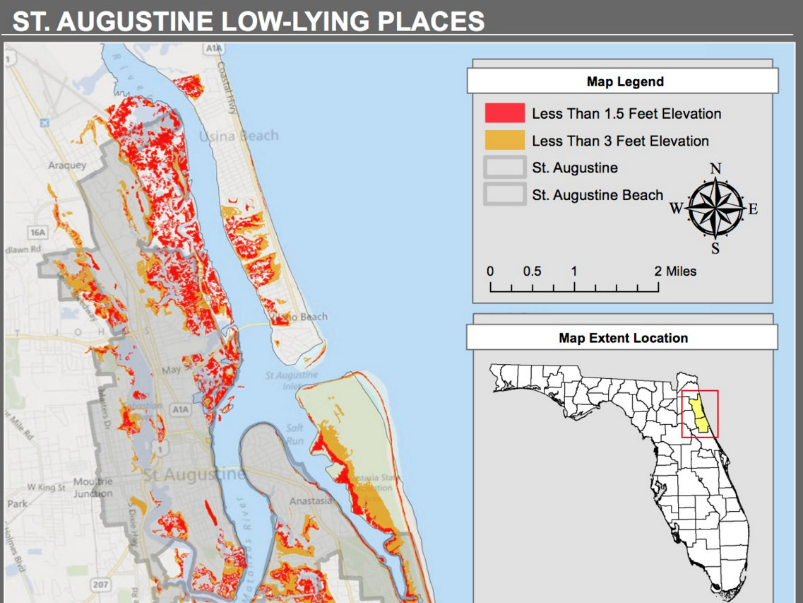

Low-lying places in St. Augustine. Credit: Planning Matanzas
By Ariel Thomas | gargoyle@flagler.edu
Most of downtown St. Augustine and much of the nearby coastline will likely be underwater by the year 2050, according to a three-year study of the Matanzas River basin.
“It’s not a question of whether it will rise, but when,” said Dr. Kathryn Frank, principal investigator of the Planning Matanzas project.
By the year 2050, the sea level in the Matanzas River basin is expected to rise half a foot to a foot and a half, the study found. By the year 2100, the level could rise to as high as five feet, with a midrange projection of three feet.
In November 2011, the Guana Tolomato Matanzas National Estuarine Research Reserve and University of Florida began the Planning Matanzas project with financial support from the National Estuarine Research Reserve.
Researchers spent the next three years studying the Matanzas River basin and the surrounding area, evaluating geography as well as ecosystems, and surveying the public to plan for eventual sea level rise.
“The goal was to initiate the planning for sea level rise in the Matanzas Basin because prior to that there was no real conversation or research at that scale,” says Frank, who was the project’s principal investigator. “This was the first effort focused on the Matanzas area, and so we wanted to generate some basic information on sea level rise.”

Kathryn Frank
Frank discussed researchers’ findings during a Feb. 10 presentation at Flagler College.
The study area has a buffer area, which includes Palm Coast, Ponte Vedra and St. Augustine.
According to Planning Matanzas’ findings, there will be an additional 511,000 people in the area by the year 2060. This means significant growth pressures in the area, and developers will likely try to expand on undeveloped land that would be impacted by sea level rise.
The project produced elevation maps that indicated which areas would be hit the worst with a 1.5- to 3-foot level sea rise. Most of downtown St. Augustine will be affected, as well as much of the coast, the study said. Marshes would turn to open water, and forests would become the new marshes.
There are a few solutions. Frank says that one of them is to retreat when sea levels do rise. Another solution is to build sea walls where needed. Residents could also lay down rocks in front of their beach homes – and some have already done that. Or authorities could expand beach nourishment projects, adding sand to the coastline.
“We’ve been talking about next-step projects,” Franks says. “We’re interested in thinking in terms of economics. What would be the costs and benefits of different strategies, and not just dollars saved, but what would be an equivalent or cost with impacts to nature?”
As for non-believers, Frank says there some people who opposed the project.
“A few individuals did express that opinion at the project’s public workshops, especially at the beginning in 2012-13,” Frank says. “When people disagreed, they either said there is no sea level rise at all, or that sea level rise is caused by natural phenomena and therefore not going to accelerate.”
For all findings, maps and other information on the Planning Matanzas project, visit planningmatanzas.org.


Be the first to comment on "Sea level rise: A looming threat"