By: Danielle Filjon
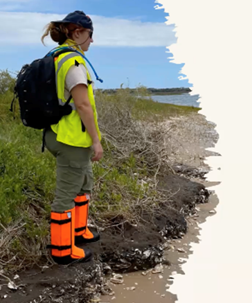
A collaboration of science and archaeological studies at the Guana-Tolomato Matanzas (GTM) reserve proves to unite ancient heritage with natural conservation. Researcher Sarah Miller and Dr. Lori Lee with Florida Public Archaeology Network (FPAN) and Flagler College are part of a team that have recently been awarded with a $600,000 grant from NOAA to research how climate change has impacted the preservation of important heritage sites, with the goal of informing heritage groups of these impacts and to preserve their historical identity.
“We are running out of time to think of new solutions to the problem of climate change, as we have seen consistent damage to the GTM reserve as well as the heritage sites that are in that area,” Miller, the project lead, said.
The GTM is what is called a National Estuarine Research (NERR) Reserve, meaning that this area is dedicated to preserving the local ecosystem, while facilitating a place where researchers can learn more about the local environment. NERR is a program that funds and encourages research across the United States’ estuaries.
What makes the GTM special, apart from its lush biodiversity, is that there are heritage sites located all around the peninsula dating back to the native tribes who lived and sustained on that land. These are of archaeological interest, especially because they are near the nation’s oldest city of St. Augustine.
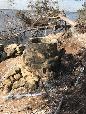
“We know from reports going back that the archaeological sites are changing dramatically,” Miller said, “I used to take my kids to a Menorcan well at the GTM, I told my kids that it was a wishing well, and if you threw a shell in and made a wish that it would come true. You could walk around it, it was like solid pavement, completely flush to the ground about 20 feet from the river. Now, the well is in the water, that amount of land has been eroded into the river.”
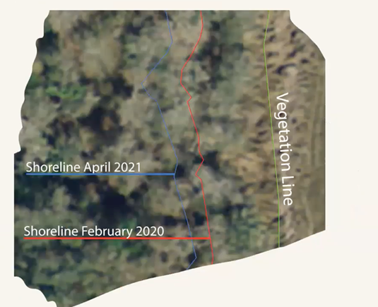
Miller says that this is due in part to the longstanding patterns of shoreline erosion and sea level rise in Florida, but this cultural marker is a striking image of the rapid damage that is being done to the river shoreline and indicates that other rivers in Florida could be unknowingly suffering the same damage.
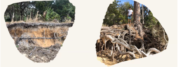
“When hurricane Matthew hit there were huge chunks taken off of the river side.” Miller said. “One year we recorded five feet lost on the eastern side of the peninsula, a tree fell and yanked all of the soil with it, and that wasn’t even after a major storm.”
“Other things like nor’easters, tidal flooding, and major storms are doing major damage that we can record in real time,” Miller said.
Sea level rise has been a very visible agent of climate change in the past few years in St. Augustine, and it is having an impact on the archeological sites on the peninsula of the GTM.
“If we have three feet of sea level rise occur, we will have 2000 archeological sites underwater, and if six feet of sea level rise is recorded, we will have about 4000 sites predicted to be underwater,” Miller said.
The goal of the project is to measure the impacts of the climate on these archeological heritage sites, and to involve members of those heritage groups in their conservation.
“The spirit of the grant is very much meant to be engaged with the public and other experts in different fields,” Miller said.
The researchers are using predictive maps of the marshes surrounding the area to see which areas of the GTM are more vulnerable to flood, so that the team can take preemptive measures mitigate the effects of the increasing damage to the area. The models can tell the researchers what the area will be like in 20 years spanning up to 100 years.
Research leading up to this collaborative project has extended back for years. The team that was awarded the grant from NOAA combines the fields of science and archaeology to discover the impacts of climate change on the ecosystem of GTM, as well as invaluable heritage sites that connect local communities to their past
“A lot of different cultures don’t know that they have a legacy at the GTM, so we want to cast a broad net of knowledge to people whose heritages are tied to this river,” Miller said.
Indigenous people such as the Seminoles, the Gullah and Geechee tribe descendants, immigrants of Menorcan and a large population of Asian fisherman have all been a part of the river’s history, and the sites around the GTM stand to uncover so much information about the cultures who sustained on the river.
“We want to reach out to these communities and say that this is one of their heritage sites, and invite them to come out and participate and learn from them,” Miller said.
The grant project is planned to last for three years, but the impact of the findings and preservation efforts spans beyond lifetimes. Between the team of experts in ecological science and archology, exploration of the rich ecosystem and cultural landmarks will uncover histories and preserve a unique part of St. Johns county.
“The program takes scientific collaboration very seriously in the most wonderful way, I’m excited to be a part of a larger community of research, Miller said, “the whole community will benefit from this grant and they really asked for very little back, they see the value of this research and that is great to see.”
Grant-specific information:
- This project is supported in part by NOAA’s National Estuarine Research Reserve System (NERRS) Science Collaborative, managed by the University of Michigan Water Center.
- The National Estuarine Research Reserve System Science Collaborative supports collaborative research that addresses coastal management problems important to the reserves. The Science Collaborative is funded by the National Oceanic and Atmospheric Administration and managed by the University of Michigan Water Center.
- Grant funds will help support undergraduate student archaeology research through Flagler College summer archaeology field schools.
Links to follow:
National Estuarine Research Reserve System (noaa.gov)

Be the first to comment on "A Heritage and Ecosystem at Risk"